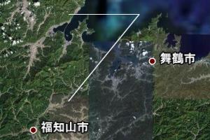
最初の2行と最後の1行は、KMLの開始と終了を示すので、変更しない。行頭などに空白も入れない。
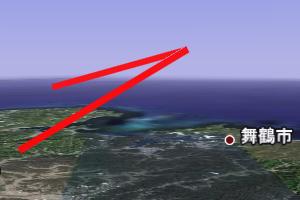
高度は、後述の"<altitudeMode>"を指定しないと、無視され、地表に置かれる。
ツアーを試してみる:
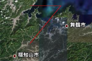
色は16進数(00-ff)で、透明度、Blue、Green、Redの順。例えば"ff0000ff"は非透明の赤になる。
"Point"の例と同様に、"Style"を最初に定義して、"styleUrl"でそのsytle idを指定することも可能。
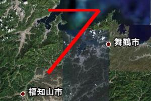
PCの環境によって線の太さが変えられない場合がある。
"Point"の例と同様。
地表面からの相対的な高さにする場合は"<altitudeMode>relativeToGround</altitudeMode>"
"YYYY-MM-DDTHH:MM:SSZ"でUTでの時刻を設定できる。
<?xml version="1.0" encoding="UTF-8"?>
<kml xmlns="http://earth.google.com/kml/2.0"> <Document>

<Placemark>
 <LineString>
  <coordinates>
	 135.7808,35.0257,0.
	 136.0,35.0,0.
	 135.2,35.6,0.
  </coordinates>
 </LineString>
</Placemark>

</Document> </kml>

タグの大文字と小文字は区別されるので注意。
左側のサイド・メニューから作成したファイルを選び、その下から作成した「パス」を選ぶ。再度メニューの下の「パス」のアイコンに三角がついたアイコン(「ツアーを再生」)を押すと、「パス」に沿ってカメラが移動するような「ツアー」が始まる。「ツアー」のカメラの向きや速度は、「設定」の中の「ツアー」で行える。
<?xml version="1.0" encoding="UTF-8"?>
<kml xmlns="http://earth.google.com/kml/2.0"> <Document>

<Placemark>
 <LineString>
  <coordinates>
	 135.7808,35.0257,0.
	 136.0,35.0,0.
	 135.2,35.6,0.
  </coordinates>
 </LineString>

 <Style>
  <LineStyle>
   <color>#ff0000ff</color>
  </LineStyle>
 </Style>
</Placemark>

</Document> </kml>

<?xml version="1.0" encoding="UTF-8"?>
<kml xmlns="http://earth.google.com/kml/2.0"> <Document>

<Placemark>
 <LineString>
  <coordinates>
	 135.7808,35.0257,0.
	 136.0,35.0,0.
	 135.2,35.6,0.
  </coordinates>
 </LineString>

 <Style>
  <LineStyle>
   <color>#ff0000ff</color>
   <width>5</width>
  </LineStyle>
 </Style>
</Placemark>

</Document> </kml>

<?xml version="1.0" encoding="UTF-8"?>
<kml xmlns="http://earth.google.com/kml/2.0"> <Document>

<Placemark>
 <LineString>
  <coordinates>
	 135.7808,35.0257,1000.
	 136.0,35.0,10000.
	 135.2,35.6,5000.
  </coordinates>
  <altitudeMode>absolute</altitudeMode>
 </LineString>

 <Style>
  <LineStyle>
   <color>#ff0000ff</color>
   <width>5</width>
  </LineStyle>
 </Style>
</Placemark>

</Document> </kml>

<?xml version="1.0" encoding="UTF-8"?>
<kml xmlns="http://earth.google.com/kml/2.0"> <Document>

<Placemark>
 <name> New Line</name>
 <TimeSpan>
  <begin>2013-12-20T03:00:00Z</begin>
  <end>2013-12-21T02:59:59Z</end>
 </TimeSpan>
 <description>This is a new line.</description>
 <LineString>
  <coordinates>
	 135.7808,35.0257,1000.
	 136.0,35.0,10000.
	 135.2,35.6,5000.
  </coordinates>
  <altitudeMode>absolute</altitudeMode>
 </LineString>

 <Style>
  <LineStyle>
   <color>#ff0000ff</color>
   <width>5</width>
  </LineStyle>
  <BalloonStyle>
  <bgColor>00664422</bgColor>
  <text><![CDATA[ $[name] <HR> $[description] <BR>
   <A HREF="http://step0ku.kugi.kyoto-u.ac.jp/">SPEL Home page</A>
  ]]> </text>
 </BalloonStyle>
 </Style>
</Placemark>

</Document> </kml>
" <begin>"で表示開始時間、 "<end>”で表示終了時間を指定する。